-->

Thursday, December 31, 2009

Happy New Year (with a look back...)

It's already 2010 on Zulu Time (0310Z as I type) but the local clock still has a couple of waning hours of the first decade of this century, so perhaps you'll bear with me as I take a few minutes to look back at what N631S and I have done in 2009.

With my full year of the regular weekly commute between the DC area and Bridgeport, I logged a lot more hours than in any previous year...to be exact, 207.2 PIC hours. Of that time, 18.4 hours were at night and 26.7 hours were in actual instrument conditions.

The log shows 18 instrument approaches this year; 15 in actual conditions and 3 "under the hood". One of the "real" approaches ended in a miss at KVKX and a diversion to my alternate at KHEF (discussed here).

One of the three practice approaches was logged on a 0.7 hour local flight in January for which I also logged 0.7 "dual received" from my friend Bob Parks. I believe that was Bob's last instructional flight at the end of two-thirds of a century as an instructor. His health began to fail soon after that and he "went West" in July. I miss him.

Through it all, N631S was a remarkably reliable machine, allowing me to make the round trip between KBDR and KVKX 35 and 1/2 times. The only notable equipment malfunction was a vacuum pump failure.

Winter is present in full force here in the northeast, so I'll be availing myself of AmTrak quite a lot in the coming weeks (as I did this week). It was nice knowing that N631S was snug in its hangar at Potomac Airfield.

It's my hope that the changing (dare I say improving?) economic climate will permit some corresponding changes in my schedule, allowing me more time in Virginia and fewer trips to KBDR. Time will tell.

I wish for all of you a healthy, safe and prosperous new year. OK, now it's time to go watch Guy Lombardo and His Royal Canadians ring in the New Year. No, wait... Not any more? Well, I guess I'll just turn in. See you all next year.

Thursday, December 24, 2009

NORAD Has Santa Contact

With links to Google Earth and videos of St. Nick in various airspaces.

Official NORAD Santa Tracker

Smiles here, for sure.

Joy of the Season

My thanks to all who visit here, with the hope that all of you have a festive and joyous holiday season!

And to all, best wishes for a healthy, safe and prosperous 2010.

Wednesday, December 23, 2009

Circuit Breaker Safety (cont'd)

A post on this blog from back in July titled Circuit Breaker Safety called attention to aspects of the NTSB report on the NASCAR Cessna 310 accident in Sanford, FL that was attributed to an uncontrollable in-flight electrical fire. In particular, it suggested that the time-honored practice of resetting any tripped circuit breaker one time is badly in need of reconsideration.

Now comes the FAA with Special Airworthiness Information Bulletin (SAIB) CE-10-11 on this topic.

I urge you to read the post linked above and then read the SAIB...and ensure that your flight SOP's are consistent with current guidance. An in-flight fire can ruin your whole day.


Tuesday, December 22, 2009

NEXRAD in the Snow

My last post was a straightforward account of the flight from KBDR to KVKX last Friday evening, arriving a bit ahead of the approaching snowstorm.

As I neared the end of the flight the NEXRAD display provided by XM Weather on my Garmin GPSmap 396 showed a broad field of snow (light blue) nearly encroaching on KVKX, but neither the METAR's at KDCA and KADW nor the view out the windshield indicated any imminent problem. I evaluated the radar display as precipitation aloft, somewhere above the existing overcast ceiling that was up around 11,000 feet MSL.

Back in the summer I'd learned a bit about the differences between NEXRAD base images and composite images of convective weather (and posted about it here and here). Now I inferred that I was seeing the same thing, but with snow.

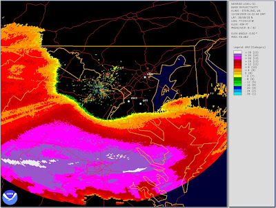
Last evening I decided to pull out archival NEXRAD images showing the base returns and composite returns for the Sterling, VA radar site at the time I was approaching KVKX on Friday. (The procedure for recovering archival NEXRAD images is outlined in this post.) In looking at the graphics, bear in mind that the terminal part of my flight was over KBWI, thence to OTT, thence direct to KVKX. Here, first, the base return image:


For scale, it's about ten nautical miles from OTT to KVKX, so the approaching weather is ten or more miles away. As it happens, snowfall did not begin at nearby KDCA until nearly two hours after the timestamp of this image.

In contrast, here is the composite return for the same time:


The XM Weather display on the Garmin did not look this bad (I wish I'd thought to photograph it). But it certainly looked more widespread and advanced than the base return image shown earlier. The takeaway is, I guess, that it's conservative to take the composite radar image at face value when planning your flight track but sometimes other evidence (e.g., METAR's, PIREP's, the Mark I Eyeball) will reveal that conditions at the base level are not nearly so problematic.

Friday, December 18, 2009

The Gathering Storm

My, but it was cold this morning when I went to the airport (KBDR) to give N631S a "pre-pre-flight" inspection in anticipation of an afternoon flight to the DC area. There was 10 knots of wind out of the north and the thermometer offered 14 Fahrenheit degrees. Really, really cold...this was the METAR:
KBDR 181152Z AUTO 34010KT 10SM CLR M10/M19 A3027 RMK AO2 SLP251

I stowed the baggage and proceeded to check out the airplane. Uh-oh...the nav lights didn't light. Cycling the switch several times was of no help. Bad news, as I was certainly not going to be arriving at KVKX before dark. So, off to see the Three Wing maintenance folks. Tony said they'd pull N631S into the hangar and have a look; I suggested that I needed to be ready for a 21Z departure as the weather from the south was threatening to arrive in my home area around 00Z.

As the day progressed I watched the weather and became a bit uncertain about the conditions I could expect at KVKX on arrival. Better move up the departure! I called ThreeWing and asked them to try to have the airplane ready for a 20Z departure.

Arriving at KBDR a bit before 20Z it was hard to believe that weather was going to be an issue. Conditions were quite pleasant, with clear skies, a zephyr of wind out of the northwest and a temperature just a degree below freezing. Here's the METAR:
KBDR 181952Z 32005KT 10SM CLR M01/M20 A3016 RMK AO2 SLP214

And, at that time, destination weather looked good. Here's the METAR for KDCA, offering little wind and a 9,000 foot ceiling:
KDCA 181952Z 08003KT 10SM BKN090 BKN250 02/M08 A3015 RMK AO2 SLP207

The forecast was indicating that snow would begin in the DC area around 01Z and I wanted to arrive well before that event. The good news today was that winds aloft were relatively light. The computer projected a flight time of about 2 hours + 14 minutes.

I was off the runway at KBDR at 2017Z. Flight conditions along the route were as forecast and N631S and I arrived in the DC area about 2220Z. As we approached KVKX for a visual approach to landing, this METAR was current at KDCA:
KDCA 182152Z 14003KT 10SM BKN110 OVC150 01/M08 A3013 RMK AO2 SLP203

I was on the runway at KVKX at 2232Z. It's good that I completed the trip in a timely fashion. Snow began to fall at KDCA at 0133Z, just two hours later.
KDCA 190139Z 08006KT 10SM -SN OVC030 00/M10 A3005 RMK AO2 SNB33 P0000

I suppose I could have been comfortable with a departure about 30 minutes later than actual, but an hour would have been cutting it too fine.

In any event, here is the flight track courtesy of FlightAware. Note the approaching weather in the southwestern quadrant.


It appears that we will be getting something between 14 and 20 inches of snow here in northern Virginia over the next 24 hours. The latest forecast for KDCA is certainly full of snow:
KDCA 182320Z 1900/1924 12004KT 5SM -SN BR BKN015 OVC030
FM190200 06007KT 1SM -SN BR BKN005 OVC010
TEMPO 1903/1905 1/2SM SN BKN001
FM190500 03009KT 1/2SM SN BKN003 OVC005
TEMPO 1905/1909 1/4SM +SN VV001
FM190900 02014G23KT 1/4SM +SN BKN001 OVC005
FM191500 36015G25KT 1/4SM +SN OVC004
FM192300 36014G23KT 3/4SM -SN BKN003 OVC010

That's calling for heavy snow from about midnight tonight until about 6 PM local time tomorrow. It's nice when the timing of a flight works out.

Wednesday, December 16, 2009

Aeroaesthetics

We who linger at airports and mess about with airplanes will occasionally, when grounded by weather or mechanical misfortune and forced to settle for hangar flying, resurrect and recycle the everlastingly interesting discussion that seeks to name "The Most Beautiful Airplane Ever Built". I think that the question is misguided. It seems to me infelicitous to force comparisons of relative aesthetic merit between radically differing types. My thought is to award four "Most Attractive" trophys to the Best of Breed in these categories: Single Engine Prop; Single Engine Jet; Multi-engine Prop and Multi-engine jet. As you might expect, I have opinions that I'm willing to share.

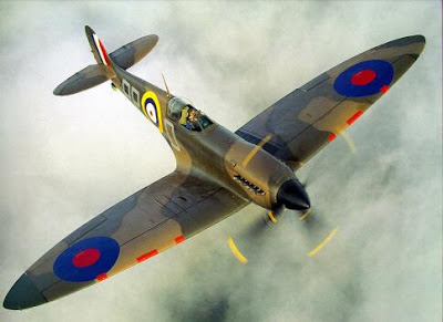
In starting with single engined propeller-driven airplanes, I immediately encounter a problem. I've never been able to settle on one exemplar to regard as the Prettiest Bird. In this category, I have to settle for a tie. On one hand there is Reg Mitchell's immortal Spitfire. For anyone who has studied aerodynamics, the perfection of the Spit's elliptical wing planform cannot help but make the heart beat faster. And all of her other lines flow harmoniously into that wonderful wing.


But on the other hand, Walter Beech's beautiful D-17 Staggerwing biplane clamors for attention. The genius of that reverse decalage inspires awe. It was agile, it was fast and above all, it was gorgeous! By all accounts, the Staggerwing has a nasty bite on the ground but any vices have to be forgiven in the presence of such beauty. (And, it's the only one of my "Beautiful Birds" that I can even dream about actually flying someday.)


So there I'm left, Staggerwing or Spitfire. Which is the more beautiful? I can't say - you decide.

When we turn to jet-propelled aircraft, life is easier. Think about single-engined jets and the grace and cleanliness of line offered by the Sabre, product of Ed Schmued's team at North American, come immediately to the fore.

The early versions of the design were straight-winged, like a P-80 or an F9F. But North American's designers were exposed to the research product of the German aerodynamicists and they understood what to do. The lovely, clean swept wing of the Sabre emerged. Other fighters have come along that will outperform the F-86 by a wide margin, but none exceed her beauty (though the Hawker Hunter comes close).


Turning to multi-engined aircraft, and starting with propeller-driven designs, there is in my mind only one answer. My friend Dennis Wolter, a profoundly talented industrial designer, said it well when he told me, "The Lockheed Constellation is the most beautiful industrial artifact ever created by man." The triple-tail, the gentle dolphin-curve of the fuselage, the slender wing supporting the four powerful Wright R-3350's are iconic and incapable of duplication. The Connie of my youth will always be, for me, the Angel of the Airways.


Again leaving behind propeller generated thrust and turning to jets, it is once more an early design (as the Sabre was) that embodies best the natural beauty enforced by natures laws of fluids. What could be more pleasing than the form of Boeing's Stratojet, the B-47? Pilots who had to fly it in defense of our nation will tell you that she was a bitch. Underpowered, and harboring lurking aerodynamic vices, the Stratojet insisted that you be on top of your game and imposed a terrible penalty if you were not. But was she not so very beautiful?


For a good number of years, that's been my take on the "Most Beautiful Airplane" question. Spit or Staggerwing for piston singles, the Sabre for a single engined jet, the Connie for the multi-engined prop and the Stratojet for a multi-engined jet. Many designs have come along, none have prompted me to change my judgement. Most certainly, the utilitarian but (in my view) unlovely A380 has no claim on exceptional beauty or grace.


But recently...in fact, yesterday...things may have changed. Yesterday, the Boeing 787 took to the sky for the first time. And she is such a beauty!


I submit that this is one really gorgeous airplane. Look at the arc of the composite wing under the force of lift. It brings to mind some great-spanned albatross gracefully alighting - or perhaps an owl swooping down over a field to snatch up a wayward vole. This image says to my heart, "Here is a creature of the sky." Many airplanes can be made to fly; this airplane belongs in the sky. Many years ago my aerodynamics professor, Dr. Jack Werner, said to us, "Don't trust an ugly airplane." His point was that nature imposes an aesthetic, and the greatest flying machines work in concert with that aesthetic and never in contravention of it. I feel that the 787 would have pleased him.

The Boeing design team deserves rich congratulations. After a troubled gestation we may find that, in their Dreamliner, they have wrought a classic. And if the B-47 Stratojet is to be displaced as the Most Beautiful Airplane in the multi-engined jet class, it's fitting if the Dreamliner, a product of the "home team", turns out to be its successor.

Monday, December 14, 2009

Ground Fog


THE FOG comes
on little cat feet.

It sits looking
over harbor and city
on silent haunches
and then moves on.

--- Carl Sandburg

The fog seems also to be fond of aerodromes. A nice layer of radiation fog was nestled across the runway when I arrived at KVKX this morning about 1210Z. According to Paul Freeman's fascinating Abandoned and Little-Known Airfields site, before KVKX was called Potomac Airfield it was Prince Georges Airpark and before that it was Rose Valley Airport. And it is in a valley. This results in pleasantly calm wind conditions much of the time, and a tendency to collect ground fog.

From midfield the trees beyond the end of Runway 6 were lost in the mist, so it seemed that visibility was less than 1/4 mile. There was naught to do but go about getting N631S ready for flight and wait for the rising sun to accomplish its thermal task.

In truth the fog wasn't a complete surprise. I'd checked the weather at about 1130Z. At that time the METAR for KDCA was encouraging:
KDCA 141052Z 19003KT 10SM SCT130 01/00 A3016
But the word from KADW was less so:
KADW 141129Z AUTO 20004KT 1SM ... BR CLR M01/M01 A3013

Still, a mile isn't bad...but it would get worse before it got better.

I took my time pre-flighting N631S while the Tanis heater warmed the engine, then started and taxied to the fuel island and topped off the tanks. By the time I'd finished fueling and checked the weather in the office again the sun was visible through the murk above the tree line, and the density of the fog seemed to be waning. The on-field weather instruments soon were claiming a mile and I could see past the end of the runway, so I called Potomac Approach for my clearance and headed out just before 14Z, about an hour later than I'd have been sans fog.

The fog was certainly thinning, but visibility was still limited - until I'd taken off and climbed to about 200 feet AGL where there was all of the blue sky and sunshine one could wish for. The balance of the trip to KBDR was uneventful, in clear VMC with a fair tailwind.

Sunday, December 13, 2009

That Wasn't So Bad!

Flight conditions for the trip on Friday evening from KBDR to KVKX were about as anticipated. Clear skies and prodigious winds out of the west-northwest. But except for a little turbulence climbing out from KBDR that might have risen to "moderate", and a few minutes of light chop near Baltimore, the flight was smooth. Slow but smooth.

For the most part I was looking at ground speeds in the mid-80's to low-90's of knots on the westbound legs (i.e., KBDR to SAX and SBJ to ETX). At one point, just before turning south near Reading, PA the ground speed dropped below 80 knots for a couple of minutes. That's about a 55 knot headwind component. In general, though, the more southerly bits of the trip went quite a lot quicker. Total tach time was 2.9 hours which is nowhere near a record. The weather was fine, I had a quick visual approach to land at KVKX, and ATC helped here and there with shortcuts to speed me on my way.

And now, a word about pre-heat systems...

I'd like to add here an unsolicited testimonial for the engine pre-heat systems supplied by Tanis Aircraft. N631S came to me with a Tanis TAS-100 system installed on the Continental O-470U engine. It is comprised of individual resistance heating elements installed in the temperature probe wells of five of the six cylinder heads and a pad heater attached to the engine block. (There's no cylinder head heater on the #3 cylinder because its probe well is occupied by the thermocouple for the original equipment CHT gage, which must remain installed and functional. This is fine because the #3 cylinder heats satisfactorily by conduction from the rest of the heater array.) When the Tanis system is connected to 110v AC power it nicely heats the engine in a couple of hours to facilitate starting in cold weather.

Friday afternoon brought the first actual cold weather start of the season, with sub-freezing temperatures at KBDR. I asked the line crew at Three Wing Flying Services to plug in N631S's Tanis after lunch, which they did. When I got to the airplane and turned the key it started as readily as if it were a warm spring day.

I've had lots of opportunities to thrash around with propane fired pre-heaters and I am fully convinced that an electric engine pre-heater (of which the Tanis system is a fine example) is one of the greatest blessings that can come to a pilot who has to start an airplane in the cold. Just make certain that you tie down within extension cord range of AC power!

Tomorrow is looking flyable!

It's raining fairly steadily here in Virginia as I write this, but it's supposed to stop by about 00Z. The forecast for tomorrow morning at 12Z is calling for a few low clouds and a scattered layer at 5,000 feet along most of the route up to Connecticut. Best of all, the freezing level is expected to be above 9,000 feet MSL almost all the way to JFK. So, it appears that a nice IFR flight can be planned.

Wednesday, December 9, 2009

We'll Try It Again!

Here it is Wednesday evening and the weather forecast for Friday is (more or less) promising for a flight from Connecticut down to the DC area. The projected map looks like this:

I can expect the high centered over eastern Tennessee to dominate the weather over the route. That will mean high clouds (if any) and no precipitation...so, no icing. But the isobars circling the low that will be far to the north over Ontario look pretty tightly wrapped. That will produce a lot of wind out of the west.

Here is the projected wind pattern for 00Z Saturday (i.e., 7 pm EST Friday evening) at 9,000 feet MSL. (I'll certainly be cleared for 8,000 feet MSL out of CT and over Eastern PA):

That looks to me like 55 to 60 knots of wind out of the west over my route to Allentown. The westbound portion of the flight looks to be a long, slow slog, and the southbound part - quartering into the strong westerly - won't be much better. I'll need to look at the winds forecast for 6,000 feet MSL, or lower. The best scenario may prove to be 8,000 until across the Newark (KEWR) arrivals, then descend to 4,000 past Allentown, Reading and Lancaster, then climb back to 6,000 to get across Baltimore (KBWI).

And I can hope that the low will have gotten far enough to the north that the winds will be steady and strong but not terribly turbulent. We shall see.

Friday, December 4, 2009

Ice Isn't Nice

Well, I've declared "AMTRAK Weather" for today. Here's why:


Conditions here in Connecticut are lovely but some unpleasantness has crept into the southern end of my proposed route. There is a stable sub-freezing cloud layer from 4,000 to 6,000 MSL reflected in the TAF's from DC up to Harrisburg. As the pirep graphic shows, there have already been a fair number of ice encounters, one described as "moderate", and there's no reason to expect things to improve.

The "Moderate" icing pirep got my attention. It was filed by the pilot of an Embraer 190 regional jet just about over KVKX, describing moderate rime ice from 5,000 to 6,000 feet. I really don't want to go there.

So I shall proceed on the ground, wishing I could be in the air but knowing that this is a lot better than the other way around.

Thursday, December 3, 2009

Hail to the Chief, Redux

He's doing it again. El Presidente is travelling to Allentown, PA tomorrow accompanied by his usual two-tier Temporary Flight Restriction (TFR). As of now the enabling NOTAM tells us that the restrictions go into effect at 1450Z and continue in force until 2140Z. Once again, the FAA has been kind enough to provide a graphic interpretation of the boundaries of the TFR:


The red line I've added to the graphic is my usual IFR clearance for a Friday afternoon trip from Connecticut to DC. As you can see, it goes right through the heart of the inner TFR core (the smaller thin red ring). Now, N631S and I are not going to be leaving KBDR any earlier than about 2130Z, so if the Man is on schedule the tents will be folded and the circus gone from town before I get there. But if he runs late I wouldn't be surprised to find the TFR extended to a later hour.

So, I'm going to file for a more southerly route - the blue line on the graphic, via Pottstown (PTW) VOR and thence on down toward Baltimore. If ATC will clear me for that route then all is well. It goes through the outer ring of the TFR (the larger thin red ring) but that's transparent to me since I'll be on an IFR flight plan. But if they insist on issuing me the usual "preferred" route then I'm just going to have to stay alert and insist on an en route deviation if required to circumvent the TFR (if it is still in effect).

That said, the good news is that the weather looks like it will cooperate. The freezing level charts are saying that it's going to be cold up there but the TAF's are all calling for high ceilings (if any), so icing shouldn't be an issue. I expect moderately strong headwinds and a flight time of about 2.8 hours. For December, it should be a nice trip.

Wednesday, December 2, 2009

Glossary

This Glossary is intended to provide some idea of the meanings of abbreviations, acronyms, jargon and terms of art that may find their way into posts without adequate definition. It will be maintained in the sidebar and will always be a work in progress, as I will add to it and refine the definitions as allowed by improved understanding and corrective inputs.

These are not definitions that I've looked up. They represent my understanding of the meanings of the terms, and that may evolve. If you think I've got something wrong, please let me know via the comment field or by e-mail (the address is in my profile).

Monday, November 30, 2009

Wheeeee!!

As of 12Z this morning there was a low pressure center over northern Vermont with a really long cold front trailing southwest from it, draping across Pennsylvania and down into the south central states. The big picture looked like this:


Ahead of the front, a strong flow from the southwest gave me hefty tailwinds for the flight from KVKX back up to Connecticut. For most of the way I was seeing ground speeds on the Garmin 530W from 165 to 170 knots. The tailwind component was between 35 and 40 knots.


At one point N631S's ground speed reached 174 knots, or just over 200 statute mph. It's not often that you get that from a Cessna 182. Wheeee! Time en route from runway to runway was 1 hour 37 minutes - I believe that's a new record.

Sunday, November 29, 2009

Today on Wisconsin Avenue...

For no other reason than that it's pleasing to the eye - National Cathedral in Washington, DC, from Wisconsin Avenue in the afternoon sunlight:


Saturday, November 28, 2009

Finally, About the Ice...

Now, a fourth and last post about my flight on Wednesday afternoon from KBDR to KVKX.

In the first post in the series, written while planning for the flight, I observed that the routing usually given me by ATC had some issues with potential icing. The clearance always starts like this: vectors to SAX, V249 to SBJ, V30 to ETX. The cruise altitude is 8,000 MSL. Their idea is to take me westbound to the north of the New York Class B airspace and then southbound to central New Jersey while above the EWR arrivals, and thence west toward Allentown. The freezing level forecast for that routing was in the band from 7,000 to 9,000.

As an aside, it seems to me that forecasts of freezing levels are usually very accurate. I've found that freezing level and temperature aloft maps from Aviation Weather Center offer remarkably good guidance even two or three days before a flight.

I considered saying "unable" and trying to insist on a routing over JFK and south along the New Jersey shore (along V16) at 6,000 MSL - but I knew that the negotiation would be time consuming and I was equally concerned about changing conditions at my destination (see post #2). So I decided to accept the clearance and work it out en route if I found any ice.

After departing into the murk I was cleared initially to climb to 5,000 MSL and then stepped up to 8,000 as I approached the Hudson River. I was watching the Outside Air Temperature (OAT) gage closely. At 8,000 feet it showed an OAT of 35 Fahrenheit degrees. OK so far, but I knew that the freezing level was sloping downward to the west so I was not out of the woods.

Understanding that the OAT gage might be optimistic, I watched the left strut and the nose of the left main gear fairing out my side window for any sign of ice accretion.

The OAT dropped to 34 degrees and I figured I'd better give the controller a "heads up". I transmitted, "New York, Skylane 631S," and got a quick "31 Sierra, go ahead."

"31 Sierra is IMC and very close to the freezing level. If I lose a degree or two we will have to work out lower," I said and the controller responded with "OK, 31 Sierra, keep me advised."

I felt better because I was sure that the controller was already thinking about how he'd deal with me if I needed to descend into airspace that was typically used for EWR inbound traffic. But fortune smiled on him (and me), the OAT held steady, and no ice formed. I made the left turn at SAX, got handed off to another sector and as I neared SBJ I was turned to the west and told to contact Allentown Approach.

Still in the clouds, I noted the OAT drop to 33 degrees. Well clear, now, of the flow of EWR arrivals, it was time to do something. I transmitted, "Allentown, November 631 Sierra, Request."

"31 Sierra, say request," came back. "31 Sierra is going to need lower to avoid icing conditions. Is 6,000 available?"

Without delay, I was cleared, "Skylane 31 Sierra, descend and maintain 6,000 feet." N631S and I descended immediately and when we leveled at 6,000 we found the OAT to be 44 degrees. I stopped worrying about ice and devoted all available worrying to ceiling and visibility at my destination.

Here's my take-away lesson from this: It's often said that if you encounter icing you need to do something about it IMMEDIATELY! I'd now add that it is even better to do something about likely icing even before the white stuff starts to collect. You'll be happier and your friendly controller will be happier.

Friday, November 27, 2009

Low IFR Departures

Wednesday morning I devoted substantial attention to a strategy for avoiding icing issues during my flight to the DC area and planning to arrive at a time when I'd have good chance of completing the approach at KVKX.

I confess I didn't pay a lot of attention to the weather there in Bridgeport. When I looked out of my window I saw pretty good visibility and an overcast that had been running about 900 to 1,100 feet MSL for hours. So I was a little surprised that it was actively drizzling when I headed over to the airport and the ceiling and visibility had certainly deteriorated.

By the time I had pre-flighted N631S, picked up my IFR clearance and started the engine, this was the current METAR:
KBDR 251835Z 08004KT 1 1/2SM BR OVC003 09/09 A3000 RMK AO2 P0001

A mile and a half visibility and a 300 foot overcast qualifies as Low IFR in anyone's book. My late instructor, Bob Parks, had gotten me to practice "zero/zero" takeoffs "under the hood". But he also told me, "Don't take off from an airport that you can't get back into."

The wind was favoring Runway 6, which is the ILS runway at KBDR. I looked at the approach plate for the ILS RWY 6. It specified a Decision Altitude of 307 feet and minimum flight visibility of 1 mile. I decided to accept the 7 foot difference between the approach DA and the reported ceiling. Off I went, feeling that I could get back in using the ILS if something surprising happened.

Edit, 11/28: A couple of friends have pointed out that since the DA on the plate is in feet MSL and the ceiling in the METAR is in feet AGL, the values in this case were exactly the same in terms of feet above the 7' TDZE (Touchdown Zone Elevation). It's not a big factor at a near-sea-level airport like KBDR, but with a more substantial field elevation the difference would be more important (and presumably, more obvious).

I was promptly into the clouds. After the New York Approach controller got me radar identified she cleared me to 5,000 feet. I broke out of the lowest layer at about 3,500 feet and was into the clear between layers.


The rest of the flight worked out as planned. On this day, no need to return to the airport emerged. If one had (like, maybe, if my vacuum pump failure had picked 25 November instead of 12 October) I was pretty comfortable that I could fly the ILS to minimums and get back on terra firma. Of course, that comfort derived in part from the fact that I know the airport well and have probably done that approach 20 times.

Looking back I ask myself:

  • Would I have been comfortable departing from an unfamiliar airport?
  • How about if the ceiling was at 200 instead of 300?
  • What if I was in an unfamiliar airplane (like a rental)?
  • Suppose N631S had just come out of significant maintenance?
  • What if it had been a couple of months since I'd flown an approach in actual IMC?

On every departure in challenging weather, there are lots of things to consider. As with most decisions, the Devil is in the details. On this occasion they added up to a "Go" decision with which I was comfortable.

Thursday, November 26, 2009

I Love It When a Plan Comes Together

That wasn't too bad. (Meaning, yesterday afternoon's flight from KBDR to KVKX, which I discussed prospectively HERE.)

When I departed Bridgeport the weather at my destination was not good. The METAR at nearby Andrews AFB said:
KADW 251737Z AUTO 13006KT 3SM BR OVC004 13/12 A2994 RMK AO2 SLP141

The 3 mile visibility in mist was all right but the 400 foot ceiling would certainly make the RNAV (GPS) RWY 6 approach at KVKX a non-starter. However, I had about 2-1/2 hours of flying ahead of me and the Terminal Area Forecasts in the region were predicting quite a bit of improvement by 19Z or so.

So I departed with the hope that things would improve and the backup plan of diverting to Manassas. The ILS approach there was solid as an alternate. And, when I next checked the Andrews weather (about 1-1/4 hour later, via the METAR screen from XM Weather on the Garmin GPSmap 396) I was pleased to see this:
KADW 251839Z AUTO 20006KT 10SM OVC008 13/13 A2994 RMK AO2 CIG 004V012 SLP141

The visibility had risen to 10 miles and the prevailing ceiling was up to 800 feet. The "CIG 004V012" (variable ceilings from 400 to 1200 feet) seemed to me to indicate a dynamic situation...the promised trend of improvement looked to be in motion.

By the time I arrived in the local area, conditions had improved quite a lot. There were scattered clouds at about 1500 feet, in sufficient quantity to make a visual approach to the airport difficult so I asked for the RNAV approach and landed without much ado. Here's the flight track for the trip, courtesy of the nice folks at FlightAware.com:


Of course, timing is everything. By the time I had N631S pulled into the hangar, the view out the back door looked like this:


The cooling air over the saturated ground was generating a nice layer of condensation fog. By the time I was driving off of the airport the fog was thick enough to limit visibility to a fraction of a mile. Had I departed one hour later, I'd have been unable to land at KVKX.

The flight also had some lessons for me about icing considerations and about departures in poor weather. I think I'll save them for later posts. For now, I wish everyone a Happy Thanksgiving!

Wednesday, November 25, 2009

This Will Be Interesting

I'm planning on a departure from KBDR about 1845Z to head for KVKX for the Thanksgiving holiday. I've filed for the "coastal" route at 6,000 feet (i.e., via JFK, down V16, over Dover and into KVKX) but according to FlightAware.com, I'm going to get "the usual route" at 8,000 feet (i.e., west to SAX, on to Allentown, Lancaster, Baltimore then into KVKX. That's the first problem. Here's why:

The forecast freezing level over eastern Pennsylvania is in the band from 7,000 to 9,000 feet. I'm not happy with the icing potential, so when I actually get the clearance I shall see if I can negotiate a reroute to something like what I filed for. If not, I'll have to depart and let ATC deal with getting me a lower altitude if I find ice.

The second problem concerns ceilings in the DC area. That 1845Z departure will likely get me into the area of KVKX around 2115Z. The TAF's show the ceilings beginning to lift a little about then:
KDCA 251123Z 2512/2612 00000KT 2SM -DZ BR SCT006 BKN009 OVC019 
     FM251600 10005KT 5SM BR OVC008 
     FM251900 21004KT P6SM OVC015 
     FM260300 VRB03KT P6SM BKN250
        
KADW 2512/2609 09006KT 3200 -DZ BR OVC013 QNH3004INS 
     BECMG 2513/2514 09006KT 2400 -DZ BR OVC004 QNH2999INS 
     TEMPO 2514/2515 OVC005 
     BECMG 2514/2515 14006KT 9999 NSW OVC007 QNH2988INS 
     BECMG 2518/2519 17006KT 9999 SCT007 OVC015 QNH2987INS 
     BECMG 2522/2523 18006KT 9999 FEW007 SCT020 QNH2987INS 
     BECMG 2605/2606 VRB06KT 0800 FG BKN002 QNH2987INS

You may recall that the Minimum Descent Altitude for the RNAV Rwy 6 approach at KVKX is 680 feet. At my ETA Andrews is expecting scattered clouds at 700 under a 1500 foot overcast; DCA is anticipating a 1500 foot overcast. If the forecasts verify I should be OK. If not, Plan 'B' is to divert to the ILS at Manassas and either rent a car or wait on the ground for an hour to see if the ceilings lift.

In any event, it should be interesting.

Monday, November 23, 2009

An Uneventful Weekend

The flight from Connecticut to the DC area on Friday evening was enjoyable. The skies were clear, the headwinds moderate and the airplane was purring like a kitten. There are few experiences in life that offer as much pleasure as a flight on a clear night.

Today's northbound flight was nearly as uneventful. The 1,500 foot ceiling made an IFR departure from KVKX a good idea, but upon reaching 5,000 feet MSL things opened up and quite soon it was a lovely flight between the layers.


N631S and I descended back through the clouds (with the help of New York Approach) and broke out at about 2,000 feet MSL around 12 miles southwest of Bridgeport for the visual approach to Rwy 6.

The next event is to fly south on Wednesday for the Thanksgiving holiday weekend in Virginia. From here, the weather looks like it will be flyable, although the forecasts call for lingering clouds and drizzle. Tomorrow will bring more useful forecasts.

Wednesday, November 18, 2009

Mid-Air Over the Hudson - Remedial Action

You'll all remember the accident that occurred last August 8th, when a Piper Saratoga and an air-tour helicopter collided in the Hudson River VFR corridor, fatally injuring all nine souls on board the two aircraft. I posted about it HERE, HERE and HERE.

The last of those posts discussed the FAA's proposed remedial actions to improve the safety of aircraft transiting or operating in the corridor. Now, I hold in my hand the recently issued 78th Edition of the New York VFR Terminal Area Chart (TAC). Published by the National Aeronautical Charting Office, it enters into effect at 0901Z tomorrow, 19 November, and it embodies the remedial actions previously discussed. Here's a clip of the affected portion:


A Regulatory Notice on the back of the chart sets out the rules in force in the Special Flight Rules Area. It begins by defining the Hudson River and East River Exclusions (i.e., excluded from the Class B airspace).

For the Hudson, it's essentially that airspace from the surface to 1,300 feet MSL between the banks of the river from the Alpine Tower in the north to the Verrazano Narrows Bridge in the south. (The East River Exclusion is mainly of interest to local helicopter and seaplane operators.)

The notice then sets out communication requirements. While operating in the exclusion, pilots must monitor the Common Traffic Advisory Frequency and announce aircraft type, position, direction and altitude at (as a minimum) these prominent points:

  • Alpine Tower
  • George Washington Bridge
  • USS Intrepid
  • Goldman Sachs Tower
  • Statue of Liberty
  • Verrazano Narrows Bridge
The notice goes on to specify requirements for aircraft operation. It imposes a maximum speed of 140 KIAS and mandates use of anti-collision lights and position/navigation lights (illumination of landing lights is recommended). Pilots must have the current New York TAC on board and be familiar with its contents.

Aircraft are required to follow the eastern bank of the river when northbound and the western bank when southbound. (Keep Right!) And, aircraft that are not landing or departing the Manhattan heliports or conducting other local operations are required to transit the exclusion at altitudes from 1,000 feet MSL to the Class B floor (i.e., 1,300 feet MSL). The transient VFR pilot thus has a 300 foot altitude band to work with. Interestingly, local operators seem not to be constrained to operate below 1,000 feet MSL.

Adjacent to the Regulatory Notice on the back of the chart is a description of the new VFR Transition Route (referred to as "the Skyline Route"). This route is a VFR "tunnel" through the Class B airspace, not an Exclusion therefrom - so the usual Class B operating rules (14 CFR 91.131) and transponder requirements (14 CFR 215) apply.

The Skyline Route overlies the Hudson River Exclusion from Alpine Tower to the Verrazano Narrows Bridge, at altitudes from 1,300 feet to 2,000 feet MSL. The description advises northbound aircraft to contact Newark (EWR) Tower and expect to fly the east bank of the river, and southbound aircraft to contact LaGuardia (LGA) Tower and expect the west bank. The specific transition altitude will be assigned by ATC, and all are advised to "remain clear of the New York Class B until receiving specific ATC approval to enter".

I confess to some surprise that the towers are the primary contacts for the Skyline Route; I'd have expected Approach Control to assume that role. If an approaching aircraft is receiving Flight Following service from New York Approach, will they be handed off to the applicable tower for the Skyline Route transition?

I look forward to giving the Skyline Route a try, probably on one of my Monday morning trips from the DC area up to Bridgeport. I expect that I'll request the route from the first New York Approach sector and then see what develops.

The more interesting experiment will be to take the Skyline Route southbound and then pick up an IFR clearance in the air over New Jersey to facilitate later entry into the Washington Special Flight Rules Area (SFRA) and Flight Restricted Zone (FRZ), where I live. If that works, it may resolve my ongoing frustration with the "preferred" routing that usually takes me over eastern Pennsylvania.

This will be interesting.

Saturday, November 14, 2009

Did I Choose Wisely?

In yesterday's post I discussed the forecasts for KVKX (my home airfield) and my decision to not fly down from KBDR and to instead take the train. So, I'm curious about what I would have encountered if I had decided to fly.

I've learned over time that the weather at nearby Andrews AFB (KADW) closely approximates conditions at KVKX. Here are the METARS (slightly edited for space) for KADW surrounding what would have been my ETA:
KADW 140015Z AUTO 01011KT 7SM -DZ OVC007 11/10 A2987 RMK AO2 RAB0001E0012
KADW 140005Z 01013KT 5SM -RA BR OVC008 11/10 A2986
KADW 132358Z 01012G19KT 7SM -DZ OVC006 11/10 A2986 RMK CIG 005V021
KADW 132355Z 01014G19KT 8SM -DZ OVC006 11/10 A2986 RMK CIG 006V021 T01120101
KADW 132353Z 01013KT 8SM -DZ OVC006 11/10 A2986 RMK CIG 006V021
KADW 132348Z AUTO 01013KT 8SM -DZ OVC009 11/10 A2987 RMK CIG 006V021

There are a couple of interesting things to note. First, we see a 1 degree C spread between the temperature and the dew point, so low ceilings are unsurprising. Over the half hour covered, the prevailing ceiling varies from 600 to 900 feet MSL with some readings as low as 500 (see, for example, "RMK CIG 005V021" in the 2358Z METAR).

With the MDA for the one approach at KVKX at 680 feet MSL, it looks like there was a good chance of my being forced to divert to my alternate, Manassas (KHEF) (which was reporting an overcast at 2000 feet MSL at the time). Since that would have entailed considerable logistical annoyance, I guess I chose widely.

Friday, November 13, 2009

'Tis an Ill Wind

And it's certainly blowing me no good today.

The 18Z TAF's are out and the forecasts for my destination area are poor:

KDCA 131821Z 1318/1418 01018G22KT 5SM -RA BR OVC015 
     FM132000 01017G22KT 4SM -DZ OVC012 
     FM140100 01014G20KT 2SM -DZ OVC009 
     FM140600 36013KT 1/2SM DZ OVC009 
     FM141000 36014KT 1SM -DZ OVC009 
     FM141600 35012KT 3SM BR OVC012
        
KADW 1317/1417 02015G25KT 9000 -RA OVC015 540209 QNH2980INS 
     TEMPO 1317/1322 3200 -RA OVC005 
     BECMG 1321/1322 36012G18KT 9000 -RA OVC009 540209 QNH2975INS
     BECMG 1400/1401 35012G18KT 9999 NSW OVC009 540209 QNH2970INS
        
KIAD 131754Z 1318/1424 01014G20KT 2SM RA BR OVC015 
     TEMPO 1318/1320 1SM RA OVC008 
     FM132000 01013G18KT 3SM -RA BR OVC012 
     FM140100 02012G20KT 1/2SM DZ OVC009 
     FM140600 36009KT 1/2SM DZ OVC009 
     FM141000 35010KT 1SM -DZ OVC008 
     FM141600 34009KT 4SM BR OVC012

If I were to depart KBDR about 22Z I'd arrive in the area of KVKX about 00Z, when the KDCA weather is expected to be 2 miles in drizzle with a 900 foot overcast. Andrews AFB is forecasting something similar. The RNAV RWY 6 approach into KVKX has a 680 foot minimum descent altitude (MDA) and a 1 mile visibility minimum. That's too close for confidence, and if I have to divert to Manassas (KHEF), the forecast for nearby Dulles (KIAD) goes down to 1/2 mile visibility at about that time. That makes my alternate a problem.

So, I've opted for the train. I have a good book to read and I should be home by about 10:30. The annoying part, of course, is that I then have to take the train back on Monday morning and the weather will probably be fine.

Thursday, November 12, 2009

Warm, Windy and Wet

Another weekend approaches and my thoughts turn to the weather that I'll need to deal with if N631S and I are going to make the flight down to the DC area. At this time of year the first thing I look at is where the freezing level is forecast to be. Here the news is good:


The expected freezing levels are well above my usual IFR altitude of 8000 feet MSL, so whatever else I may be concerned with, icing should not be a factor.

Next, let's look at the "big picture":


The cyclonic flow around that low pressure center off of Cape Hatteras has been pumping wet maritime air into the Mid-Atlantic region for a while now, and the map shows an area of drizzle, showers and rain affecting the area of interest - eastern PA, MD, DC and VA. It'll be a warm flight, but a wet one.

The low is fairly deep and the isobars surrounding it are a bit crowded. This will give me brisk winds both aloft and on the surface from the northeast. In fact, FltPlan.Com is telling me to expect a time en route of under two hours and an average tailwind of 15 knots. Wheee!

It's too early to get pertinent Terminal Area Forecasts (TAF's) for airports near home at time of arrival (namely DCA and Andrews), but the TAF's for the big airports now go out 30 hours, so I can look at BWI and Dulles. Through 00Z on the 14th, they don't look too bad:

KBWI 121734Z 1218/1324 04015G25KT 6SM -RA SCT020 OVC030 
     FM122200 03017G27KT 6SM -RA BKN015 OVC020 
     FM130600 02016G23KT 5SM -RA BR OVC012 
     FM131300 36015G25KT 4SM -RA BKN012 OVC020
        
KIAD 121734Z 1218/1324 02013G19KT 6SM -RA SCT020 OVC025 
     FM130100 01014G24KT 5SM -RA BKN015 OVC025 
     FM131300 01013G24KT 5SM -RA OVC012

For Baltimore, four miles visibility in light rain with broken clouds at 1200 feet and an overcast at 2000. For Dulles, 5 miles visibility in light rain, and overcast at 1200. If conditions at KVKX are nearly that good, the GPS approach to runway 6 will work out just fine. The things I will need to watch as flight time draws nearer are the ceiling and visibility forecasts for KDCA and KADW. If they are much lower, I could find myself needing to divert to the ILS at Manassas.

And then there's the wind. Both Baltimore and Dulles anticipate winds from the north at about 15 knots with gusts to 25. The winds at KVKX, sheltered in the valley, ought to be a bit less vigorous, but that's manageable in any case.

A warm, windy and wet flight. Final decisions will await tomorrow's data.

Wednesday, November 11, 2009

On this Veterans' Day...

From For the Fallen by Laurence Binyon:

They went with songs to the battle, they were young,
Straight of limb, true of eye, steady and aglow.
They were staunch to the end against odds uncounted,
They fell with their faces to the foe.

They shall grow not old, as we that are left grow old;
Age shall not weary them, nor the years condemn.
At the going down of the sun and in the morning
We will remember them.

Let us remember on this day that we need to be thankful every day for the service of those who have given much, or given all, to protect us and all that we hold dear.

Sunday, November 8, 2009

Today at KMGJ

No trip to DC for me this weekend. A social engagement last evening required my continued presence here in Connecticut, so here I stayed. With some time today and beautiful VMC weather on hand, I gathered up a good friend and flew N631S from Bridgeport to Orange County Airport (KMGJ) in Montgomery, NY. Orange County is a very pleasant non-towered field about six miles west of Stewart International Airport (KSWF). It offers quite a good on-field restaurant, "Rick's Runway Cafe", and good airplane watching.

One visitor was this really spiffy North American T-6 Texan. Its owner had flown it up from White Plains (KHPN).

Across the apron from the restaurant, near the gas pumps, rested a derelict twin that I just didn't recognize. This airplane is in really sad shape. The tires are flat, the bottom blade of the right prop is digging into the asphalt, the right wingtip is damaged and the paint is flaking in many places.

My friend came to the rescue. After staring at the old airplane for a few minutes he said, "I think it's a Beagle. It's British." And it turns out he's right! A bit of Google research turned up this link which provides specifications and history, and some photos of one in quite a bit better shape. I believe (based on the 2-bladed props) that the airplane at KMGJ is a Beagle B.206S Series 1, powered by Continental GIO-470 engines. (The later Series 2 used more powerful GTSIO-520's.) The FAA Aircraft Registry site shows 10 Series 1's currently holding N-numbers.

The flight over and back was a pleasant chance to hand-fly the airplane in good weather - something I probably ought to do more of. With a little luck, next weekend will bring another trip to Virginia.

Monday, November 2, 2009

Airport Micro-climates

During the first part of last Friday's flight from KBDR down to KVKX there was great VMC on top and a lovely sunset to enjoy.


It was quite warm (about 15 degrees C at 8,000 feet MSL) and there was a strong southerly flow at lower altitudes ahead of the advancing cold front. Most stations below that lower layer were reporting ceilings between 2000 and 3000 MSL.


Sunset happened about 2205Z and by the time I was over Baltimore it was dark. The usual routine is to cross KBWI at 6,000 (headed direct to OTT). ATC will give me a descent to 4,000 a few minutes after crossing over their major airport. So I was not surprised to hear: "Skylane 31 Sierra, descend and maintain 4,000. No weather or traffic information available at Potomac; Washington National is reporting overcast 2,700, wind 170 at 10. Expect the visual approach at VKX."

I expected that, but I wasn't entirely happy with it. Washington National (KDCA) is 7.5 miles NNW of Potomac Airfield. Controllers will usually look at what's happening at DCA and surmise that things can't be too different over at KVKX. I have learned that DCA weather is a poor predictor of conditions at KVKX. So, I responded to the nice Potomac Approach controller: "Skylane 31 Sierra, thanks for that weather, could you please tell me the current wind and ceiling at Andrews?" That got me, "Sure. Stand by."

I already knew the answers, courtesy of XM Weather on the Garmin GPSmap 396. Andrews AFB is 5.5 miles northeast of KVKX and has weather that is much more likely than DCA's to be consistent with conditions at KVKX. KADW was reporting a ceiling of 1,900 feet MSL. The Minimum Vectoring Altitude between OTT and KVKX is 1,700. Not great for trying the visual approach.

The next transmission from the controller was, "Skylane 31 Sierra, Andrews is reporting a 1,900 foot overcast, wind 160 at 8. Ummm, we'll get you down to 1,700 down there and if you don't have good ground contact we'll run you out for the approach."

My answer was, "That sounds good to me, 31 Sierra."

Just before reaching OTT I was cleared to descend to 2,000 feet MSL, and the controller asked for flight conditions. "In and out of the bases," was the response. Then he asked, "I'll get you down to 1,700 in a mile or two - do you still want to try the visual?"

"I'd like the RNAV 6 approach to VKX, please," was the obvious decision. Twenty minutes later, after a routine approach (see below), I was on the ground at home.


Airports all have their own little micro-climates. Even a little local knowledge can be very helpful. The IFR system offers a full toolkit for these kinds of situations and one might as well use it.

Courtesy of FlightAware, here's the track for the 2.9 hour flight:


Thursday, October 29, 2009

Automation-Induced Complacency


Image shamelessly stolen from NASA ASRS Callback #315

It would seem that you can't conduct an aviation-related blog without commenting on the saga of the peripatetic Northwest Flight 188. You know - the one where the flight crew reportedly went "Heads-Down-and-Locked" over their personal laptops while 'George' flew the airplane past the intended destination (KMSP) at FL370 and on for another 150 miles into the wilds of darkest Wisconsin. It was the Mother of all LOSA (Loss of Situational Awareness) incidents.

Now it's reported that the FAA has issued an emergency revocation order for the certificates of the Captain and First Officer involved. They can appeal the order to the NTSB but based on the circumstances reported in the press their prospects of continued employment as professional aviators appear bleak. Perhaps that's as it should be. It is certainly easy to imagine ways in which their inattention to duty could have led to catastrophe. But at the same time, I'd suggest that to a degree they were set up.

Based on what's been revealed to date, it looks like this flight crew fell victim to Automation-Induced Complacency. And this is not in any way a new problem. Consider the following quote:

"Another problem concerns the new automatic systems which are coming into service with newer aircraft and being added to older aircraft. Flightcrews become more reliant upon the functioning of sophisticated avionics systems, and their associated automation, to fly the airplane. This is increasingly so as the reliability of such equipment improves. Basic control of the aircraft and supervision of the flight's progress by instrument indications diminish as other more pressing tasks in the cockpit attract attention because of the overreliance on such automatic equipment.

Pilot's testimony indicated that dependence on the reliability and capability of the autopilot is actually greater than anticipated in its early design and its certification. This is particularly true in the cruise phase of flight....

In any event, good pilot practices and company training dictate that one pilot will monitor the progress of the aircraft at all times and under all circumstances."[emphasis added]

Those words come from an NTSB report dated 14 June 1973. The subject is the crash, on the preceding 29 December, of Eastern Airlines Flight 401 in the Florida Everglades. That was the L-1011 aboard which the entire crew was busy troubleshooting an indicator light problem while the airplane - with the autopilot inadvertantly disengaged - spiralled slowly down into the swamp.

And here we are, 36 years later, with another crew allowing themselves to be distracted to the point where no one was flying the airplane! Fortunately, this time nobody died.

"During the long ages between dawn and sunrise, I'm thankful we didn't make the Spirit of St. Louis a stable plane. The very instability which makes it difficult to fly blind or hold an accurate course at night now guards me against excessive errors. It's again a case of the plane and me compensating for each other."
-- Charles A. Lindbergh, "The Spirit of St. Louis"

Flying in the Lone Eagle's day was the polar opposite of today. The problems revolved around task saturation, i.e., there was too much to do. But aviators like Lindbergh and Doolittle and Rickenbacker nonetheless excelled. It was an environment where human beings could, with training, do well. Yet, as aviation matured, new capabilities of pilot and aircraft were needed. Necessity brought forth the autopilot.

"I pay those guys to fly, so let them fly. I'll be damned if I'll pay them to just sit there."
-- reportedly, Eddie Rickenbacker, CEO Eastern Airlines. Eastern aircraft were some of the last to be equipped with autopilots, his pilots saying if it wasn't in Captain Eddie's SPAD he won't buy it. Quoted in 'Human Factors in Multi-Crew Flight Operations' by Orlady & Orlady.

In spite of Capt. Eddie's resistance, flight systems automation has become ubiquitous and now it looks like problems are arising from crews having not enough to do. The terms in current vogue for the flight crew are PF and PM - that's Pilot Flying and Pilot Monitoring. But for long stretches in cruise there is precious little flying for the PF to do, and the PM is probably, like all humans, rather poor at monitoring.

In a 2002 paper entitled Enhancing Flight-crew Monitoring Skills Can Increase Flight Safety, Capts. Robert Sumwalt & Ronald Thomas and NASA's Dr. Key Dismukes point out that:

"...although monitoring may seem intuitive and easy, in reality, continuous and effective monitoring is not natural. In fact, it is most natural to do things as you think of them, instead of delaying them until later. However...an effective monitoring strategy involves sometimes delaying some tasks until less vulnerable periods. It is also not natural to stop doing something in the middle of the task to scan instruments (monitor). Instead, people prefer to complete the task before stopping. However, effective monitoring requires a more-or-less constant scan of instruments."

And, quoting an earlier Air Transport Assn. Automation Sub-Committee paper:

"...serious errors do not occur frequently which can lead to boredom and complacency. 'A low probability, high-criticality error is exactly the one that must be caught and corrected.'" [emphasis added]

And so we have this highly experienced flight crew on NWA188 whiling away the hours from KSAN to KMSP with 'George' doing all the work. Ostensibly, of course, they are "monitoring systems" but you can only devote so much attention to static displays and creeping moving maps. So, being human and fallible, they turn their attention to "more pressing matters" -- like the arcane new pilot scheduling software. And the share of their attention devoted to "monitoring" their progress through the night sky falls to...zero. It's just unlikely enough to be the truth.

I think of the times I've been humming along over eastern Pennsylvania with 'George' in control of N631S and the GPS in control of 'George' and me, both the PF and the PM, with no flying to do and not a lot to monitor. If there were a distraction available, I might be vulnerable. So, while I can't excuse the guys up front on NWA188, I can see how they got in trouble.

The airlines may want to look into ways to keep the flight crew engaged with the airplane during extended low-workload periods. There is, for example, the concept of Adaptive Automation which uses novel approaches to task allocation and task partitioning to be responsive to changes in workload and operator behavior. The system could deliberately cede tasks to the pilots during low-workload periods simply to maintain a minimum level of operator involvement.

For my part, I think I'll just continue to keep Rule 1 in mind: Always fly the airplane!

Sunday, October 25, 2009

Post #100

As it happens, I put up the first post on this blog eight months ago - 25 February 09. This being the 100th post, I seem to have been holding forth 12.5 times each month.

According to data collected by statcounter.com, there have been roughly 14 visits/day over the last two weeks. A sizable percentage of the visitors are responding to search-engine hits (mostly Google).

A few posts in the archive seem to be "best sellers", as they keep getting Google-inspired visits. In order of "popularity", these include:

Statcounter.com also provides the geographic location and IP address of visitors. You get to know the folks who come back more than a few times. I seem to have "fans" in (among other places) South Bend, IN (someone who works the midnight shift, judging from the times he/she visits), Stillwater, OK (possibly two folks, one of whom logs on from OSU), Overland Park, KS and Hammond, IN. To these folks and others who have taken the time to stop by and read the blog, I'd like to say, "Thanks!"

Saturday, October 24, 2009

About Last Night...

I took note previously of the TFR attendant to the President's visit to Stamford, CT. For my departure from KBDR (which was in the area covered by the "outer ring" TFR but outside the core "no-fly" area), the whole thing was pretty much transparent to the IFR user. The only change from usual practices occurred when Clearance Delivery asked that I give them a "heads-up" call five minutes before I was ready to taxi so that they could coordinate the departure. That's not normally needed.

After departure everything proceeded as usual. I did hear one conversation wherein ATC was helping a pilot who'd intended to go to KHPN figure out where he wanted to land to wait for that airport to open to General Aviation traffic. (White Plains was in the area of the "core" TFR.)

With the approach of the cold front (something that seems to be happening on a seven-day cycle timed to provide the week's most interesting weather on Friday evening), I got to fly through the schmoo over most of eastern Pennsylvania and on down to Baltimore.

Just past KBWI at 6000 feet, N631S and I flew through a rather small but fairly intense piece of weather isolated from the bulk of the stuff, with about three minutes of moderate precip and light-to-moderate turbulence. Scanning the dials, I noticed a loss of air speed. Glancing over at the manifold pressure gage, I saw that it was down to about 18 inches instead of the 22 or so I'd expect at that altitude. Aha! Carburetor icing! The carb inlet air temp gage was just below the top of the yellow arc at about 4 degrees C. I immediately applied full carb heat. The engine went a little bit rough and there was one "hiccup" as, presumably, a piece of ice broke loose and passed through the engine as a slug of water. But in less than a minute the manifold pressure was back to expected levels and the aircraft accelerated to the speed I'd been getting before. I reduced the carb heat to just the amount needed to keep the gage out of the yellow and had no further issue.

The good news is that the area right around home had good VMC, so the visual approach into KVKX was on offer. As a minor complication to end my day, the Potomac Approach controller needed to keep me high until quite close in and I wound up with a "slam-dunk" approach. From 2000 feet and 2+ miles out, I wasn't able to get down for a normal approach to landing so I wound up executing a go-around. Good practice.

Friday, October 23, 2009

Hail to the Chief

The President is coming to town for his own political purposes, and bringing with him his traveling circus of Temporary Flight Restrictions. From 2030Z to 0010Z tonight there are a pair of TFR's centered on a point on the Carmel (CMK) 189 radial at 14.2nm. I believe that's one of the hotels in Stamford where the party is going to be.

The folks in charge of security theater have promulgated a NOTAM in typically opaque language warning off all of us aviators. Fortunately our good friends at the FAA have provided an explanatory web site that provides guidance we can actually understand. They even include graphics:

As you can see, Bridgeport (KBDR) is outside the inner TFR (which is the real "no fly zone") and within the outer ring, where operations are possible as long as you are on an active flight plan and in touch with ATC.

If I depart, as planned, shortly after 21Z, I will have to be sure to get a turn to the north right away - which Approach Control usually issues to me anyway. This doesn't really take me any further out of my way than I'm accustomed to. It's just that the penalties for messing up are rather more severe.

Oh, yes, the weather. The forecast is for light rain showers in the area on arrival around 00Z. There may be some issues with low ceilings...I've got Manassas for an alternate.

Wednesday, October 21, 2009

Stupid Pilot Trick

A video clip that showed up recently on YouTube has been generating quite a bit of commentary on the aviation internet forums I frequent. Recorded by a passenger, it shows an unintended encounter with IMC and a resulting really close encounter with the local trees and bushes - to the point where the aircraft sustains impact damage but manages to return safely to the airport. The consensus of the pilot community seems to be that this pilot displays monumentally poor judgment. If you haven't yet seen this, here it is. Have a look (about 3 minutes running time).


I don't take issue with the position that the behavior shown here is about as bad as it can get. It is astounding that the flight shown didn't terminate with a smoking hole on the side of the mountain. What does give me pause is an underlying current in the commentary implying, "Hey, I'd never do that." Not smugness, just a feeling of disbelief that the observer could at any time even approach that level of stupidity.

To anyone who just can't conceive of ever being the central player in such a misadventure, I have a book I'd like to commend to you.


In Darker Shades of Blue: The Rogue Pilot Tony Kern explores the phenomenon of the aviator who inexplicably throws caution to the winds and behaves in ways that seem to invite fatal mishap. He explores many case studies and delves into the root causes of the FAA's familiar five Hazardous Attitudes (found in AC60-22 on Aeronautical Decision Making, available at: Link 1 and Link2). I won't try to summarize Dr. Kern's work here (please find and read the book). But at the end he concludes that, on any given day and for any given flight, every one of us harbors the potential to become that rogue pilot who abandons discipline with catastrophic results. Awareness of this potential is our sharpest tool in avoiding the terrible consequences of such behavior.

So I return to the Bonanza pilot seen in the linked video, not to condone him (he surely will - and should - face consequences for his actions, but for now they won't be fatal to anyone), but to acknowledge that there, but for the exercise of constant vigilance, go even the best of us.