My last post was a straightforward account of the flight from KBDR to KVKX last Friday evening, arriving a bit ahead of the approaching snowstorm.
As I neared the end of the flight the NEXRAD display provided by XM Weather on my Garmin GPSmap 396 showed a broad field of snow (light blue) nearly encroaching on KVKX, but neither the METAR's at KDCA and KADW nor the view out the windshield indicated any imminent problem. I evaluated the radar display as precipitation aloft, somewhere above the existing overcast ceiling that was up around 11,000 feet MSL.
Back in the summer I'd learned a bit about the differences between NEXRAD base images and composite images of convective weather (and posted about it here and here). Now I inferred that I was seeing the same thing, but with snow.
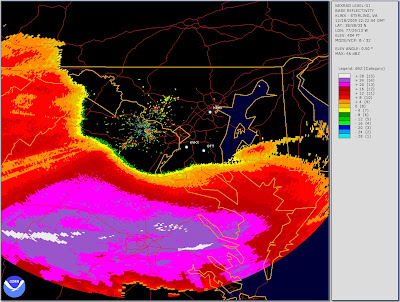
Last evening I decided to pull out archival NEXRAD images showing the base returns and composite returns for the Sterling, VA radar site at the time I was approaching KVKX on Friday. (The procedure for recovering archival NEXRAD images is outlined in this post.) In looking at the graphics, bear in mind that the terminal part of my flight was over KBWI, thence to OTT, thence direct to KVKX. Here, first, the base return image:
For scale, it's about ten nautical miles from OTT to KVKX, so the approaching weather is ten or more miles away. As it happens, snowfall did not begin at nearby KDCA until nearly two hours after the timestamp of this image.
In contrast, here is the composite return for the same time:
The XM Weather display on the Garmin did not look this bad (I wish I'd thought to photograph it). But it certainly looked more widespread and advanced than the base return image shown earlier. The takeaway is, I guess, that it's conservative to take the composite radar image at face value when planning your flight track but sometimes other evidence (e.g., METAR's, PIREP's, the Mark I Eyeball) will reveal that conditions at the base level are not nearly so problematic.


No comments:
Post a Comment