For no reason other than this: a total of 100 posts in 2010 is more satisfying than a mere 99.

For no reason other than this: a total of 100 posts in 2010 is more satisfying than a mere 99.
New Year's Eve is a good time to look back at the twelve months just passed, as I did just a year ago in this posting. Now I have a second full year of experience with my nearly-every-week commute between Virginia and Connecticut so comparisons are possible.
N631S finished the year with 4,031.5 hours on the tach, having flown 177.9 hours in 2010. That's about 14% less than the 2009 total of 207.2 hours. Yet I made the round trip 37 and 1/2 times this year, twice more than last year. Maybe 31 Sierra is getting faster?
Actually, I suspect that the difference is attributable, at least in part, to better weather. (I discussed this earlier, in part, in this posting.) I logged 12.9 hours in actual IMC (instrument meteorological conditions) this year, less than half of 2009's 26.7 hours. Oddly, this year's total of 14 approaches flown in actual conditions is only down from last year by one.
Here's a possible partial explanation: This year many more of these approaches were flown into Bridgeport (KBDR), and those approaches can be flown rather efficiently. Not one was into Potomac Airfield (KVKX), in contrast with 2009 when I flew the RNAV Rwy 6 approach there eight times. That approach requires a considerable excursion to the southwest and will add a fair bit of time to the flight.
The same rationale may explain, in part, the fact that time logged at night for 2010 at 9.2 hours was just half the 18.4 night hours logged in 2009.
It's obvious that all of this couldn't have occurred unless N631S was an admirably reliable machine. In 2010 I experienced only two equipment failures and neither of these caused me to miss a flight I'd otherwise have taken. In July a brake master cylinder attachment bracket failed while taxiing after landing (discussed in this posting), and in August a wiring problem caused the autopilot to fail in IMC (discussed in this posting and in this one).
For me, 2010 has been a rewarding and enjoyable year of aviating. I hope it's been so for all of you as well. As always I am grateful for your visits (and especially comments!), and I hope you've found this blog interesting and perhaps on occasion even useful. So, Happy New Year! I hope that we all will enjoy a healthful, prosperous and safe 2011.
Tweet
As anticipated in the previous posting, yesterday's flight from KBDR in Connecticut down to KVKX in the DC area was pleasant and uneventful. For most of the trip N631S and I cruised under altostratus layers a couple of thousand fee above us, mostly in temperatures above freezing. The photo below is typical.

We did come upon a cold (27F) cloud layer at 8,000 feet MSL just north of Lancaster (KLNS). I requested a descent to 6,000 in expectation of warmer air. The descent, quickly approved by Harrisburg approach, also put us below the clouds, and that was the extent of IMC for the day.
Here's the track for the flight, courtesy of FlightAware.com:

I'd be remiss if I neglected to report an embarrassing moment that occurred prior to departure. I am theological about leaning the fuel mixture going to N631S's big O-470U engine aggressively right after start. I go to full-rich for the run-up and leave it thus for takeoff. Leaning for ground op's keeps the spark plugs from fouling and is generally good for the engine. Here is an excerpt from the gospel according to Capt. John Deakin (Pelican's Perch #77):
Running [very] lean (lean of peak power) on the ground also absolutely prevents you from taking off with the mixture leaned. This is not true if you take half-measures: Either do it this way, or leave it full rich. I don't care how faithfully you use checklists, you will someday attempt a takeoff with the mixture leaned. If you have properly leaned for taxi, the engine will simply wheeze and lose power, making it very obvious you're not going anywhere...Well, this was the time I forgot to go to full rich for the run-up. I am now able to offer personal testimony that an aggressively leaned Continental O-470U will not keep running if one mag is shut off. I re-started immediately...maybe nobody noticed?
Lean it aggressively on the ground, or not at all!


The Terminal Area Forecasts (TAF's) for the afternoon and evening look good. Here are the 15Z forecasts issued for my departure and arrival locations.
KBDR 301435Z 3015/3112 VRB03KT P6SM SCT250
     TEMPO 3015/3017 5SM HZ
     FM301700 27005KT P6SM BKN200
     FM302200 VRB03KT P6SM SCT050 BKN100
     TEMPO 3109/3112 3SM BR

KDCA 301454Z 3015/3112 20003KT P6SM SCT150 BKN200
     FM301700 14005KT P6SM BKN100 OVC120
     FM302000 17006KT P6SM SCT060 BKN090
     FM310000 19005KT P6SM SCT090 SCT120
     FM310600 19003KT P6SM FEW100 BKN200
Bridgeport is expecting light winds from the west and some high cirrus, while DCA is calling for scattered clouds at 6,000 feet under a 9,000 foot overcast and light winds from the south.So it looks like I can anticipate an uneventful trip for what will probably be N631S's last flight of 2010.
As usual, all of the figures below can be enlarged with a click.


Again, the link to the engine that generates these comparison curves is: Google Ngram Viewer. Have some fun with it, but use caution, as it tends to be addicting.
Winter operations present a challenging environment that demands thorough planning, continuous assessment of conditions and careful management of options. N631S's flight last Friday from KBDR to KVKX brought all of that home for me.
I'd been watching the weather carefully for a day or so. It had been cold and dry in the northeast but an approaching system was promising to make things interesting. The low would pass to the north but we'd be getting a sequence of warm front, precipitation and cold front. The warm front was due at about flight time and might have precipitation associated with it.
Here are excerpts from 12Z Friday morning Terminal Area Forecasts (TAF's) with the expected weather for the time period that I'd be interested in.
TAF KBDR 101122Z 1012/1112 ...
FM101800 17006KT P6SM BKN080 OVC100
FM102200 17006KT P6SM BKN040 OVC070...

TAF KJFK 101122Z 1012/1118 ...
FM101700 17008KT P6SM BKN080 OVC100
FM102100 17008KT P6SM BKN040 OVC070...

TAF KABE 101131Z 1012/1112 ...
FM101700 18008KT P6SM SCT030 BKN060...

TAF KRDG 101131Z 1012/1112 ...
FM101700 18008KT P6SM SCT030 BKN060
FM102300 00000KT P6SM BKN100...

TAF KMDT 101134Z 1012/1112 ...
FM101700 16008KT P6SM BKN060
FM102000 18007KT P6SM BKN050...

TAF KBWI 101132Z 1012/1118 ...
FM101800 19009KT P6SM SCT035 SCT060 BKN120
FM102300 16004KT P6SM SCT150=

TAF KDCA 101132Z 1012/1112 ...
FM101700 18011KT P6SM SCT050 SCT080 BKN150
FM102300 17005KT P6SM SCT150=
(Note: Prior period TAF's (and a cornucopia of other climatological data) can be gotten from Ogimet, a wonderful resource developed by Guillermo Ballester Valor, meteorologist from the Spanish Meteorological Institute (INM).)All that is not so bad. I was particularly interested in Allentown (KABE), Reading (KRDG) and Harrisburg (KMDT) because the weather would be approaching from the west and anything unpleasant would get there first. Those stations were showing some lower clouds (SCT030, scattered at 3,000) than the New York area. So on general principals I filed for an eastern route over New Jersey: KBDR DPK V16 ENO V312 OTT direct. Not that I expected to get that.
Things got a little more interesting as the day progressed. When the 18Z TAF's came up (a bit before 1:00 PM local time), the Pennsylvania stations had gotten a bit more pessimistic:
TAF KABE 101732Z 1018/1118 17007KT P6SM SCT030 BKN060
FM102300 VRB03KT P6SM BKN120...

KRDG 102222Z 1022/1118 17008KT P6SM SCT030 BKN060
TEMPO 1022/1024 P6SM -SN...

TAF KMDT 101740Z 1018/1118 18010G15KT 1 1/2SM -SN OVC017
TEMPO 1018/1019 3SM -SN OVC025
FM101930 19008KT P6SM BKN060 FM102000 18007KT P6SM BKN050...
The Harrisburg (KMDT) TAF got my attention. At 18Z they were having continuous light snow with a mile and a half visibility under a 1,700 foot overcast. That's not good at all. The snow was gone from the forecast by 1930Z...but did I want to bet that way? I took another look at Atlantic City:
TAF KACY 101732Z 1018/1118 15008KT P6SM SCT030 BKN060
FM102300 VRB03KT P6SM BKN080=...
That looked a whole lot better than Pennsylvania, with scattered to broken layers improving to a high ceiling by 23Z. The forecasts for KBWI and KDCA were holding up nicely and the departure was looking acceptable:
TAF KBDR 101737Z 1018/1118 08006KT P6SM SCT040 BKN110 BKN250
FM102100 15006KT P6SM VCSH BKN040 OVC070...

TAF KJFK 101737Z 1018/1124 13007KT P6SM SCT040 BKN110 OVC250
FM102100 16008KT P6SM BKN040 OVC070...
The one thing in the KBDR TAF that would need watching was the "VCSH" (showers in the vicinity) after 21Z. And, of course, I'd had an e-mail from FltPlan.com advising me to expect the routing over Pennsylvania as my clearance. I resolved to (a) be on my way prior to 21Z, and (b) insist on the New Jersey routing.I had called the FBO earlier and asked them to plug in N631S's Tanis pre-heat system by noon. When I got to KBDR about 20Z, the engine was all toasty and ready to go. I quickly accomplished the pre-flight inspection and picked up the hand-held radio:
Me: "Bridgeport Clearance Delivery, November 631 Sierra."I started the engine, to allow it to warm up while I waited for ATC to figure out what to do about me. I was a bit surprised (in a pleasant way) when Bridgeport tower came back to me with an excellent clearance: Vectors to DPK V16 ENO V268 SWANN Direct. ENO is the Smyrna VOR near Dover AFB; V268 departs ENO to the west and SWANN is 35 miles along that airway. This was good!
KBDR: "631 Sierra, go ahead."
Me: "631 Sierra is filed IFR to VKX. I'm advised that you're going to read me a clearance via Sparta to Solberg to East Texas, etc. I am going to say "Unable" to that clearance due to icing conditions over Pennsylvania. Request you go back to Appraoch and get something for me that starts out 'vectors to Deer Park, V16...'"
KBDR: "631 Sierra, stand by."
I entered the route into the Garmin GNS-530 and called for taxi clearance. As I taxied toward Runway 6 it began to snow. The forecast "VCSH" was a bit early.
This was the METAR in effect when I got to the airport:
KBDR 101952Z 09005KT 10SM OVC085 M02/M10 A3037 RMK AO2 SLP284
Snow? What snow? But the NEXRAD display on my GPS-396 showed there were bands of light snow, oriented N-S, crossing the area. And one band had arrived at KBDR. I sat at the hold-short line waiting for a Baron that was on the ILS 6 approach, and thinking about the snow. I heard the voice of my old instructor, Bob Parks, almost as though it was coming from the unoccupied seat next to me:"Snow's not a problem as long as it's dry snow. It doesn't stick to the airplane. But it makes it very hard to see."The Baron emerged from the cloud on short final. After it touched down, tower asked the pilot for flight conditions and braking action. He reported, "Flight visibility is three miles, ceiling indefinite. Braking action is good."
As the Baron turned off I reviewed my situation.
As N631S and I lifted off at 2028Z the following METAR was posted for KBDR:
KBDR 102028Z 08003KT 4SM -SN OVC026 M02/M08 A3037 RMK AO2 SNB24
The AWOS system thought the ceiling was at 2,600 feet but we were in the schmoo at about 900. It had been snowing for four minutes. I'd been given a heading of 090 by the tower and told to contact Approach. The New York controller cleared me up to 3,000 feet and turned me to the south. Climbing out in IMC, I added two things to my normal scan: the leading edge of the wing strut and the OAT. If any ice began to adhere to the airframe it would show up first on the strut. And, as long as the temperature kept dropping with altitude, I would probably be in good shape. If I saw a rise in temperature (indicating an inversion), I'd be concerned that the snow might change to mixed precipitation and result in ice accumulation.


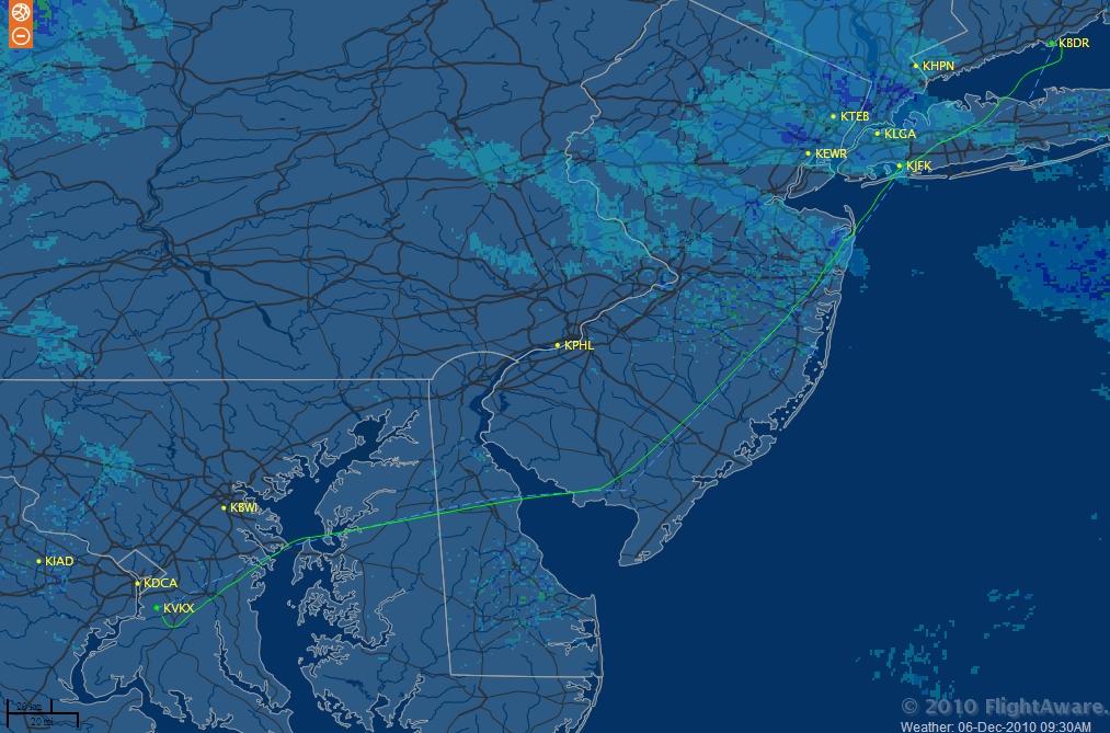
The screenshot at left shows the snow band I'd just left behind, moving off to the east. Other precipitation appears downrange beyond JFK, but at 6,000 feet (and later back down to 4,000) it was never a factor for the flight. The forecasts of improving weather from southern New Jersey into the DC area verified nicely. The remainder of the trip, as evening fell, was quite pleasant.
Below, the flight track courtesy of FlightAware.com. The weather depiction in that image corresponds to the time that N631S and I were about 50 NM past JFK.

It was the usual Monday morning trip from Potomac Airfield (KVKX) to Bridgeport (KBDR). I got to the airport soon after 0700, opened N631S's hangar and got the pre-heat system plugged in. The temperature was 30F; I decided that 40 minutes of pre-heat was in order.
In due course I pulled the airplane out, put the car into the hangar, closed the hangar doors and started the big Continental engine. It was perfectly happy to turn over and run and I taxied to the fuel island to fill the tanks (which I'd skipped on Friday evening when I was anxious to be home). Park and shut down; set up ladder; attach grounding cable; insert fuel card in card reader; select fuel pump; start pump; pull out about 25 feet of hose; climb ladder; remove fuel cap; squeeze trigger. Nothing. Nada. No stream of fuel from the nozzle. The pump would not run continuously.
OK. Use colorful language; push airplane back so the other pump can reach it. Repeat much of the procedure above. This time 100LL emerges from the nozzle in a gratifying stream.
I went into the FBO office and left a note advising that Pump #2 was hors d'combat and called Mt. Vernon TRACON to collect my clearance. The weather at VKX was clear but the forecast was calling for scattered to broken clouds over Maryland, Delaware and southern New Jersey anywhere from 4,000 to 5,500 MSL. In the hope of avoiding those layers I'd filed for the Victor 1 (V1) airway at 7,000 feet.
It's been my experience that layers advertised as "scattered" or "broken" are usually not very thick, so about 2,000 feet above the bases will get you to "on top". With a layer described as "overcast" all bets are off.
What I got in my clearance was V16 with an initial altitude of 7,000 feet. This is where a little specific knowledge of ATC's quirks is very handy. If I get the V1 route I can stay at 7,000 as far as McGuire (AFB) Approach airspace, but if I am on the more westerly V16 I'll be forced down to 5,000 feet by Dover (AFB) Approach to avoid conflicting with KPHL arrivals.
There's no point in talking to Mt. Vernon about this. I accept the clearance with the plan of negotiating with Dover Approach to trade V16 for V1. Back outside, start up N631S, and take off. Wheels up time was 0824.
The climb to 7,000 feet put me nicely on top and in the sunshine. The outside air temperature at that altitude was a snappy 5F. All good. But I needed to think about the weather situation at the northern end of the route. KJFK was reporting light snow (see the blue radar returns on the FlightAware.com screen-shot above). The airports surrounding New York were reporting broken to overcast cloud decks from 3,500 to 5,500 feet. And that was a potential problem because...
On the route I was flying it is customary upon reaching the Coyle VOR (CYN) to have McGuire Approach say, "November 31 Sierra, descend and maintain 5,000 feet." They seem to have an agreement with New York Approach to feed them northbound traffic at that altitude. And, if McGuire brought me down to 5,000 I would probably be in the thick of the cloud cover in the New York Class B airspace with a pretty high probability of ice accumulation.
So when Atlantic City Approach told me to contact McGuire, I checked in with, "McGuire Approach, Skylane 631 Sierra, level 7,000 with a request."
"November 631 Sierra, McGuire altimeter 29.62, what is you're request."
"You need to descend me to 5,000 somewhere around Coyle, but that altitude will put me into the cloud layer over New York. Could you ask them if I could cross the Class Bravo at 7,000 for icing avoidance."
"November 631 Sierra, it's on request." I'd never seen that work before; but I never asked that way before.
And, a few minutes later I got, "November 631 Sierra, you can plan on 7,000." Yes! Have I mentioned that I really like ATC?
As N631S and I approached the southern border of New York Approach airspace the heaviest cloud coverage was just south of the outer bay. It looked a little better crossing Long Island, and Bridgeport wasn't bad at all. Here are some of the relevant METAR's, arranged from south to north:
KMJX 061435Z AUTO 29016G25KT 10SM FEW050 SCT060 OVC075 01/M09 A2961 RMK AO1
KBLM 061435Z AUTO 28015G24KT 10SM BKN048 OVC055 00/M11 A2960 RMK AO1
KJFK 061451Z 28023G29KT 8SM -SN SCT029 BKN038 BKN048 BKN250 01/M07 A2955 RMK AO2 PK WND 27029/1449 SNE1356B33 SLP006 P0000 60000 T00061067 58011 $
KBDR 061452Z 29017G24KT 10SM FEW035 SCT110 M01/M09 A2948 RMK AO2 SLP982 T10061089 58015
MJX is Miller Airpark in Toms River, NJ, well south of New York. They were reporting few clouds at 5,000, scattered at 6,000 and overcast at 7,500 - really fairly nice. BLM (Belmar/Monmouth County), within New York Approach airspace, was a different story with broken to overcast layers from 4,800 to 5,500. As I passed over KBLM, N631S was in and out of the tops at 7,000 - never long enough for any ice to accrete. In fact, at 5F it may well be too cold for ice to adhere to the airframe.JFK had light snow and scattered to broken layers at 2,900, 3,800, 4,800 and way up at 25,000 feet. At 7,000 feet I was in the clear. As N631S and I crossed Kennedy and made the north-eastward turn toward Bridgeport they asked me to descend to 5,000. Ahead I could see that the clouds were opening up so I didn't feel concerned. I had some light turbulence in the descent but no ice.
Before I got down to 5,000 feet Approach issued a descent to 3,000 and that got me under all of the cloud layers. The flight across a very churned up Long Island Sound was bumpy but brief and the wind at KBDR was 17 knots gusting to 24, right down the middle of Runway 29. N631S and I were on the ground at 1033.
Of course, changing the oil is one of the items of Preventive Maintenance authorized for accomplishment by the holder of a Private Pilot's certificate under 14 CFR 43 Appendix A Section (c).
To change the oil in a Cessna 182 the following items are essential:


The third item is up there in the darkness beyond the cowl flap. The air inlet duct from the air filter is secured to the carburetor inlet air box on each side by a 1/4-turn fastener. If you are fortunate they will be "wing-nut" sorts of an animals and you can reach way up there and separate them manually. If you are not so fortunate you may have to engage them with an appropriate screwdriver, which is more difficult and requires more colorful language.
Once all three connections are disconnected you can unfasten the 1/4-turn Cleco fasteners that secure the lower cowl in place (taking care not to forget the two that are way down at the bottom just to the left and right of the nose gear strut) and carefully lower the cowl clear of the exhaust pipe and carry it away. (This is where your helper earns his keep.)


I unscrew the filter as quickly as possible, keeping a roll of paper towel handy.
Once the filter has been detached and extracted and the area has been cleaned up, untwist and remove any left-over safety wire that may still be hanging from the filter adapter. Then, take a good look at the filter adapter. There is an Airworthiness Directive, AD 96-12-22, that applies to Cessna 182 aircraft. It requires inspection of the oil filter adapter at every oil change and in particular focuses on the integrity of the torque putty applied to the joint at the base of the adapter. (If the putty is broken it indicates that the filter adapter is not secure.) This is one of the few inspections that can be accomplished by a Private Pilot, and it has to be logged in the airplane's maintenance records.
The oil has been draining for a few minutes by this time so it's a good opportunity to capture a small sample of the used oil to send off for spectrometric analysis. I use the kits provided by Aviation Laboratories of Houston, Texas. They provide very nice on-line reports of their analytical results.


With the oil in the engine, pull the airplane out of the hangar and start it up. Watch the oil pressure closely, and if the gage doesn't respond in a few seconds, shut down and find out why not. Don't run the engine too long, as it's un-cowled and therefore isn't being cooled properly. After a couple of minutes shut down and inspect the engine for any evidence of leaks.
If everything looks tight and dry you can re-cowl the airplane (usually the hardest part of the entire job). You'll need your helper again to get the lower cowl in place. Remember to re-secure the two fasteners for the air-box duct, the two cowl flap clevises and the landing light connector - which will need a couple of new Ty-raps.
And that's it! All that's left is to make the appropriate entry in the engine's maintenance log, send off the oil sample to the lab, and cut open the filter to inspect the media for stray metal (which process will be the subject of a future post.)
 |
| Photo: Paul King Mansfield |
The question got me to thinking about, first, why do I fly? And second, why do all of us fly? At first, specious answers suggested themselves:
But none of the easy answers really captured the motivation that leads me to engage in a costly activity with (let's face it) heightened risk, on a regular basis. In the end, this is the response I gave to Toria's question:
Why do I fly?I fly because in flying there is no pretense, no prevarication, no dishonesty. The airplane doesn't know your family name or your pedigree. It can't read your resumé or check your references. It cares not about the color of your skin, or your gender, or where, if anywhere, you bow before your god.
The airplane only cares that your hand and your mind and your heart can become one with it when, together, you have to deal with the fierce crosswind, or the frontal weather, or the icy threats of winter.
The airplane looks back at you and says, "Do or do not. There is no 'try'." But when you give the airplane what it needs from you, it returns a satisfaction that is rare in our world. And that is a priceless gift.
But that's just me. Other pilots certainly respond most powerfully to other satisfactions. Some relish the freedom of flying a J-3 Cub from a rural grass strip and cruising, low and slow, over the countryside. Others may crave the adrenalin rush that comes with taking a fully aerobatic Yak-52 to the edge of its performance envelope for an air show crowd. The warbird owner may sacrifice many things for the feeling that when he keeps his 65 year old T-6 flying he is in touch with, and part of, the amazing tradition of aviation in America.
I'm pretty certain that there are almost as many reasons to fly as there are aviators. And that's a wonderful thing because it preserves the variety and vitality of aviation.
So, my flying friends, think it over for a few minutes. Of all of the reasons to fly, all of the rewards to be had, which one speaks most clearly to you? And when you have it figured out, go on over to Toria's blog and leave your answer to her question.
| -- As You Like It (II, vii) |
I could cheat a bit by lining up toward the left side of the 150-foot-wide runway and angling my initial takeoff roll into the wind to cut down the crosswind angle. I'll see what the actual conditions are when the time comes.

But the skies are clear and I'm going home for the holiday weekend. Life is good! To all who visit here, safe travels and a fine Thanksgiving.
This!


The weather gods delivered as promised for this flight. It was a perfectly clear, moonlit night with temperatures aloft well above freezing and a tailwind! Ground speed for most of the trip down from Bridgeport was around 145 knots and the time en-route runway-to-runway was 2 hours + 7 minutes. What a superb flight!

Looking ahead to Friday, it seems to be shaping up as a lovely evening to fly from KBDR in Bridgeport to KVKX in the DC area. All of the weather indicators are good.


The trough that dragged cold arctic air down here to give us a chill the last few days has moved off to the east and the freezing level will be high. The chart at left from ADDS shows the isotherms at the 725mb level (about 9,000 feet). My route will be well south of the 0 degree curve, so even if I can find a cloud it will just be wet. And both the NAM and GFS Model Output Statistics are predicting ceilings above 12,000 feet and excellent visibility across the route.

This is about as nice a weather picture as one could hope for in mid-November. If the forecasts verify, I'm expecting a beautiful evening flight.
Tweet
It's better to be on the ground wishing you were in the air, than the other way around. Or so I've been told.

Of course, the forecast for Monday morning, when I will need to return to Connecticut, calls for fine, clear weather.
Tweet
This week we had as a house-guest for a few days a young lady from Europe. On Tuesday she was headed on to Seattle and we took her to KDCA for her flight, Alaska Airlines Flight 3. Our young friend expressed the hope that her flight would not experience much turbulence. I was aware that the middle of the country was enjoying a day of very energetic and unpleasant weather, so I was minimally reassuring.
Alaska Airlines' Dispatcher for Flight 3 was contemplating the same weather system, and this (courtesy of FlightAware.com) is the solution that he or she came up with:

Pretty slick. A good example of the shortest distance between two points not being a straight line (or, in this case, a great circle course). And it's equally true for a Skylane or a 737-800. Of course, we get the fun of being our own Dispatcher.
I'd been watching the development of the system (first discussed here and then here). Now it was time to deal with it.
The freezing level was predicted to slope from 8,000 feet over North Carolina down to 4,000 feet over Massachusetts. I was concerned that the usual ATC preferred route (west to Pennsylvania then south, at 8,000 to pass over the KEWR arrivals) would encounter icing, so I filed for a route across JFK and down through New Jersey at 6,000.

Of course, I got an e-mailed notification from FlightAware.com that ATC was intending to issue the "usual route": SAX V249 SBJ V30 ETX V39 LRP V93 BAL direct. They wanted me to go where the weather was and I wanted to go where it wasn't.

N631S: "Bridgeport Clearance, Skylane 631 Sierra IFR to VKX; you're going to read me a clearance that starts with "radar vectors to Sparta." I'm going to be unable to accept that due to icing conditions on that route. I need something that starts with "Vectors to Deer Park, thence Victor 16."
KBDR Clearance: "31 Sierra, you want to go V16 over JFK?"
N631S: "Affirmative."
KBDR Clearance: "OK, stand by, let me talk to them."
I'd been here before and wasn't very optimistic about New York Approach being in a cooperative mood. They really want the southbound traffic to swing out to the west. But as the minutes passed, I started to be a bit hopeful. After all, it doesn't take any time at all to say, "NO!" Sure enough, after ten minutes I heard:
KBDR Clearance: "31 Sierra, we've got it, just give me a couple more minutes to work out the other end of the route," followed two minutes later with, "31 Sierra, advise ready to copy."
N631S: "31 Sierra, go ahead."
The clearance I got was: Vectors to DPK V16 DIXIE V1 ATR V308 BILIT direct DCA direct. The back half of that would have to be re-negotiated en route - there was no way that Potomac Approach would let me go to DCA, and Waterloo (ATR) was out of the way - but the front half served to get me outta town. Sold!
The METAR in effect at KBDR when I took off was:
KBDR 151952Z 27020G29KT 10SM FEW040 BKN110 13/05 A2936 RMK PK WND 31033/19270
20 knots of wind gusting to 29 is fairly sporty, but it was nearly aligned with Runway 29 and so not a problem. The lower cloud deck had opened up to "few at 4000" above the airport, but I could see more solid cloud coverage to the south.I was happy to find that my assigned altitude of 6,000 feet initially put me on top of the cloud deck. By the time I got to JFK the tops had risen a few hundred feet so that I was in and out of the layer. The temperature aloft was 30F but I was never in the clouds long enough to accumulate any ice.
In due course, New York Approach handed me off to McGuire and McGuire handed me off to Atlantic City. It was time to do something about that clearance.
N631S: "Atlantic City Approach, Skylane 631 Sierra, request."
A.C. Approach: "31 Sierra, go ahead."
N631S: "My current routing has me going by way of Waterloo and DCA and I know Potomac Approach doesn't want me going to DCA. Can you work out something like after LEEAH, V268 to Smyrna then V379 to Nottingham thence direct?"
A.C. Approach: "31 Sierra, let me talk to Dover and see what they're willing to do."

The balance of the trip was uneventful. And once again I am appreciative of ATC's professionalism and flexibility, essential to making this flight on a day with interesting weather.

Looking back at the logs, I see that the first 1,000 hours took about six years, as did the second. The third 1,000 hours took 12 and 1/2 years and the last thousand took nine years. Over the years, the aircraft has built time at an average rate of 119.1 hours/year. N631S has been with me since late September of 2004; since then we've flown 755 hours together.
It's interesting that the Vref aircraft valuation service provided by AOPA says that the fleet average total time for '77 Skylanes is 3960 hours; as of now N631S is almost perfectly average.

KBDR 142352Z 1500/1524 04010KT 2SM +RA BR BKN015 OVC025
     FM150400 34010KT 5SM -RA BKN015 OVC040
     FM150800 32013G20KT P6SM SCT015 BKN040
     FM151500 30018G28KT P6SM BKN040
     FM151800 29020G33KT P6SM BKN040

KDCA 142329Z 1500/1524 33009KT P6SM FEW080 SCT250
     FM150600 27010G18KT P6SM SCT060
     FM151300 28010G20KT P6SM SCT060
     FM151600 30015G25KT P6SM BKN060
     FM152200 29010KT P6SM SCT250
For a 21Z departure, the southern end of the trip would be fine but the departure presents issues. The surface winds will be sporty, 20 knots gusting to 33 from the northwest, but that's not the problem. The problem is the 4,000 foot ceiling considered in light of the anticipated freezing level. Here's the latest on that:
At left, the forecast temperatures at the 800mb level at 00Z tomorrow (about 6,000 feet MSL). As noted in the previous post, the 8,000 foot routing over eastern Pennsylvania just isn't going to work. In fact, unless actual conditions are better than the current forecast, 6,000 feet over JFK is also not likely to work. What I really need is 4,000 feet over JFK and I rather doubt that New York Approach will be happy to give me that.
So here's Plan A: File for 6,000 over JFK thence Victor 16 down through New Jersey, and if the 18Z weather says that is unwise, refile for 4,000 and see how ATC feels about that. Plan B would be to depart VFR and fly to New Jersey via the Hudson River Skyline Route at about 2,500 feet, proceeding to Toms River (KMJX); land there and file IFR at 4,000 feet from there to KVKX.
And, I guess, Plan C is AmTrak.
Looking ahead to Friday's weather has me in an unhappy mood. Here is a picture of the reason for my discontent, courtesy of NOAA's Aviationweather.gov:

With my usual departure time from Bridgeport's KBDR of around 21Z, it doesn't look like I'll be dealing with much precipitation. But I anticipate low to medium ceiling heights and a fairly low freezing level (reference that 0 deg. isotherm). It seems unlikely that the "usual routing", at 8,000 feet over to Sparta and Allentown, will work due to probable icing conditions. I might get away with a route over JFK and down the New Jersey coast at 6,000 feet. If I can get my friends at ATC to clear me that way.
If ATC is uncooperative, I might (as a last resort) be able to file to an intermediate destination in New Jersey (possibly KMJX, Miller Airpark in Toms River), land there, and refile to KVKX from that point. That would probably game the system but it's irritating to have to contemplate such subterfuge.
We shall await developments...
+LWX1004101151Z.jpg)
KADW 041149Z AUTO 35013KT 8SM RA OVC005 10/10 A3009 RMK AO2 CIG 004V007 SLP193
KDCA 041147Z 35012KT 2 1/2SM RA BR BKN014 BKN022 OVC038 11/09 A3012 P0002
For once, conditions at KVKX were closer to those at KDCA than KADW. On climbout, N631S entered the overcast at about 1,200 feet, well above the 500 foot ceiling Andrews was reporting.
+OKX1004101351Z.jpg)
